
VERMONT SCENIC BYWAYS
The Crossroad of Vermont Byway
Follow Route 4 through central Vermont for mountain scenery, village visits and local history. Plan a drive with time for Rutland, Killington, Woodstock and Quechee.
Woodstock photograph: New England Photography
Home / Vermont scenic byways / Crossroad of Vermont Byway
ACROSS CENTRAL VERMONT
A Route 4 road trip with time to explore
Vermont Tourism describes the Crossroad of Vermont Byway as a 50-mile east–west route from Rutland to the New Hampshire border, including Killington and Woodstock. Use it to connect an outdoor outing, a village lunch and a cultural stop.
You do not need to visit every attraction in one trip. Choose the part of the corridor closest to your base and give your main activity enough time before adding another destination.
Published byway length: 50 miles.
Main road: U.S. Route 4.
Direction: east–west across central Vermont.
Allow extra time: for attraction detours, meals and your return drive.
CHOOSE YOUR STOPS
Explore the byway in three parts
These groupings help organize your trip; they are not a timed tour or turn-by-turn directions. Check each attraction’s visitor address, since some stops require leaving Route 4.
Rutland, Mendon & Killington
Start with time in town or choose a mountain-area outing. Mendon and Killington offer a base for outdoor activities; Gifford Woods State Park is an option if you want to explore woodland scenery.
Planning tip: Pick the activity before estimating the day’s driving. A substantial hike or a resort visit needs its own block of time and current access information.
Woodstock: village time, farming & conservation
Consider Billings Farm & Museum or Marsh-Billings-Rockefeller National Historical Park as the focus of your visit. Leave room for a meal and a look around Woodstock instead of rushing from one entrance to the next.
Planning tip: These are separate attractions. Check their individual admission, tour and visitor arrangements before combining them.
Quechee & the eastern part of the drive
Build a stop around Quechee Gorge or the VINS Nature Center. Choose the experience that suits your group, then allow time to park, explore and continue comfortably toward your destination.
Planning tip: Use official visitor guidance to choose a walk or viewing area. A brief scenic stop and a longer nature-center visit make different demands on your schedule.
GIVE THE DAY A FOCUS
Four places to build your itinerary around
Choose a main attraction and one nearby addition. Confirm seasonal schedules, reservations and visitor entrances directly before traveling.
Gifford Woods State Park
Explore a park known for its old-growth northern hardwood forest. Check the state’s visitor information for access and conditions, and select a walk that fits your group’s ability and available time.
Billings Farm & Museum
Make time for a working dairy farm and exhibits about Vermont farm life in Woodstock. Review the daily program and current visitor information before deciding how much of the day to spend here.
Marsh-Billings-Rockefeller National Historical Park
Explore the story of conservation and land stewardship in Woodstock. Check the National Park Service’s current program and tour information; a walking visit and a reserved tour may require different plans.
Quechee Gorge & Quechee State Park
Use the park’s official information to plan a scenic stop or suitable walk. Check current trail access, weather and walking surfaces, and stay within designated visitor areas.
ANOTHER QUECHEE OPTION
Explore the VINS Nature Center
The Vermont Institute of Natural Science is based in Quechee and focuses on environmental education, research and avian rehabilitation. Its Nature Center offers another way to make a stop about learning as well as scenery.
Review current exhibits, programs and trail information before your visit. If you also want to see the gorge, allow separate time for both rather than assuming they form one quick stop.
MAKE TIME FOR WOODSTOCK
A village stop in every season
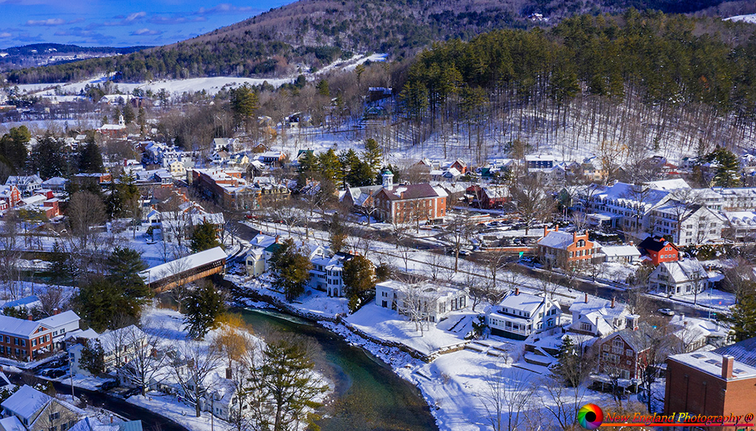
Photograph: New England Photography.
A town visit gives the drive a change of pace. Choose a place to park, leave time for a meal and browse at your own speed before continuing along the corridor.
In winter, consider daylight and walking conditions when deciding how much to fit in. In busier travel periods, leave a buffer for parking and any attraction reservations.
If a covered bridge is part of your plans, use the county guide to choose a specific stop and calculate the extra travel time.
A FLEXIBLE DAY TRIP
A suggested Crossroad of Vermont itinerary
Morning: Begin near your accommodation and visit one main attraction. From the western part of the corridor, this might mean a town stop or a suitable outdoor outing before heading east.
Midday: Choose a village for lunch. If Woodstock is part of the plan, decide whether you want a short town visit or enough time for a farm, museum or park experience.
Afternoon: Add a nearby highlight, such as a Quechee-area stop, only if it fits comfortably. Keep time for the return drive or arrival at your overnight destination.
Reverse the direction if that suits your base. This is an outline for choosing a few stops, not a promise that every attraction can fit into one day.
For a longer stay
Split the western and eastern parts of the corridor across separate days. A longer stay leaves room for a substantial walk, a guided visit or more time in town without repeatedly rushing back to the car.
Choose accommodation after deciding your main activities. Check arrival arrangements and meal options, and keep a weather-dependent outing flexible.
PLAN FOR THE SEASON
Foliage drives, summer outings & winter visits
Summer & fall
Combine a cultural visit with an outdoor stop in warmer weather. Choose walks that suit your group, carry water and a layer, and check the forecast before leaving.
For foliage season, check current reports close to your visit. Color varies with location and weather, so include attractions you will enjoy without relying on a guaranteed peak date.
Winter & spring
Allow extra time for a winter drive and check current road conditions. Confirm the details of any ski-area or other seasonal activity separately from your scenic-drive plan.
For spring outings, check trails and visitor facilities before adding a walk. Keep an indoor alternative available if changing conditions make an outdoor stop unsuitable.
MAPS & PRACTICAL RESOURCES
Plan your Crossroad of Vermont Byway route
The original downloadable map is retained as a historical reference; its filename identifies it as a 2011 map. Use the statewide brochure and official guide for route context, then check current navigation and road conditions for your trip.
Before you leave
- Save your route and exact attraction addresses before setting out.
- Confirm opening hours, admission and any tour reservations directly.
- Plan meals, fuel and rest stops around your activities.
- Check walking distances, surfaces and entrance access for your group.
- Use designated parking and respect private roads and property.
- Include detours and the return journey in your driving estimate.
HELPFUL ANSWERS
Crossroad of Vermont Byway FAQs
How long is the Crossroad of Vermont Byway?
Vermont Tourism lists it as 50 miles. Attraction detours, your starting point and the return journey can make your own trip longer.
Which road does the byway follow?
It follows the Route 4 corridor across central Vermont. The state tourism description connects Rutland with the New Hampshire border, including Killington and Woodstock.
Can I enjoy it in one day?
Choose a few stops for a day trip. Allow more time if you want substantial hikes, several museums or lengthy attraction visits.
What are some places to stop?
Options include Gifford Woods State Park, Billings Farm & Museum, Marsh-Billings-Rockefeller National Historical Park, Quechee Gorge and the VINS Nature Center.
Are Billings Farm and the national park the same attraction?
No. They are separate places to visit in Woodstock. Check each organization’s current admission, reservations and visitor information.
Is the byway suitable for a foliage trip?
It can be part of an autumn itinerary. Check current reports, keep the schedule flexible and include activities you will enjoy regardless of the color.
Should I use the original downloadable map for navigation?
Use it as a historical planning reference. Check current directions, road conditions and attraction entrances before traveling.
Keep exploring Vermont
Compare more scenic drives or plan another day along the Route 100 corridor.
Route reference: Vermont Tourism’s scenic byways guide.